2015öNōx ŖwÅpīŚ¼ÄxēćÄæŗÓ ŖCŖOé╠æÕŖwōÖéŲé╠ŗżō»ŖwÅpŖłō«Äxēć
(āvāŹāWāFāNāgNo.1-4 Ŗ┬ŗ½éŲŖJöŁé╠āWāIāCāōātāHā}āeāBāNāX)
Ģ±ŹÉÅæ
āvāŹāWāFāNāgæŃĢ\ü@īĄü@¢įŚč
Ŗ┬ŗ½ÅŅĢ±ŖwĢöŗ│Ä÷ü@īōÉŁŹ¶üEāüāfāBāAīżŗåē╚
Toward A Cultural City of Kesennuma From 3.11
in Tohoku Japan
Charrette Design Workshop on the Reconstruction of Matsuiwa-Omose
Area
Wanglin
Yan
Faculty of Environment and Information Studies
Keio University
1.
Introduction
Kesennuma
City is a city located at the central of Sanriku
costal region and the northeast corner of Miyagi Prefecture with 334 km2
of land and 65,430 population (2015/09). The ria landscape forms the most part of the city with
serrated coastal lines, drowned valleys, and deep bays beneficiary for
aquaculture, especially oysters and scallops. Fishery industry provides major
job chances for the city itself and the region. In the Great East Japan
Earthquake of March 11, 2011, an earthquake registering nearly 6 on the
Japanese seismic scale (comparable with Richter scale from 1 to 6) was measured
in the city center area, and nearly 5 in Motoyoshi
area, the south part of the city. The tsunami subsequently swept the bay area,
landed big ships, flooded the downtown and main business districts. Leaked oil from the broken tanks induced disastrous fires burnt Shishiori, another population dense area. The city as a
whole counted 1359 casualties, including 220 missing persons and 108
related-deaths, damaged 15,815 houses and 9500 families.
The big fire and the landed ship in in Shishiori
demonstrated the severity of the disaster. Half year later after the event, the
city authorized the Reconstruction plan in October of 2013. The Master plan set
the goal of reconstruction in ten years while the first 5 years is intensive
reconstruction period for a safe, workable, livable, sustainable, joyful, slow
and smart city in 10 years. The master plan was embodied by seven pillars:
reconstruction of the infrastructure, rehabilitation of disaster management,
renewal of industry, restoration of nature-human dynamics, enhancement of
healthcare and wellness, improvement of learning and education, and promotion
of community activities, with 31 sub-projects in total. For the realization of
the plan, it calls for cooperation of all stakeholders including citizens,
industrials, government and NPOs etc.
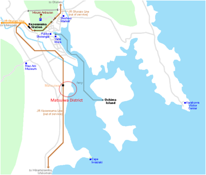
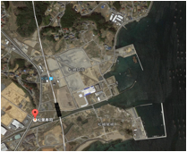
Fig.1 Layout of Kesennuma City and the
targeted area
Five years has passed, and the city has been gradually recovering. The rubles
were cleaned in first three years, and the road infrastructures are in
reconstruction. The low land in city center were readjusted and elevated for
industrial and commercial activities while the reconstruction of other
inundated areas are largely delayed. The inundated low lands under the tsunami
line are regulated for residence. Citizens who lived there have three choices:
1) move to higher land if land is available personally and affordable for a
detached houses by themselves independently; 2) relocate to higher land
collectively if land is available by group and affordable for a detached house
independently; 3) relocate to a unit of city-owned condominiums in cheap rent.
While the projects of relocation are steadily progressed, the reconstruction of
inundated areas is largely delayed, particularly the land out of city center. This
is partly because of capacity of human and financial resources. The main reason
of delay comes from the uncertainty of the land use policy. What to rebuild in
the remote and shrinking city? The population of the city has decreased by 9.4%
in recent five years after the disaster.
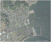
The District of Matsuiwa, the target area of this workshop, is one of such an
areas. The district is located 5km south of the city center. The houses along
the coast and the river were swept away by the tsunami. The shrine of Ozaki at
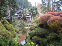
the cape is located on a top of a hill where more than 30 evacuees survived. Enunkan, a historical house of Ayukai
family since Edo era and also the home of Mr. Naofumi
Ochiai, a famous Japanese literature in Meiji era,
just sits at the north above the tsunami line, in front of the bay with a
beautiful Japanese garden and a nice view of the harbor.
|
Fig.2. The historical house of Enunkan |
Fig.3 The Shrine of Ozaki that saved 30 evacuees from Tsunami |
|
|
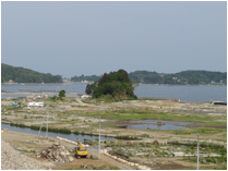
Fig.5 After the tsunami |
Even with such a nice location and rich cultural-natural resources the
municipality owns no idea about the reconstruction of the area. Previous residents,
landowners and citizens are interested in rebuilding the district as a compound
zone for recreation, learning, and communication. They have started to talk and
have developed some ideas. They do not know how to represent the ideas
professionally in harmony with the landscape and culture, and how the ideas
could be implemented and contribute to the future of the city. This might be
the good chance to reconstruct the area with participation of public through
bottom up process. In context, a design charrette was organised to design a reconstruction
plan with participation of experts and local residents during Sep 7 to 11, 2015.
The aims of this workshop are:
1)
Understanding the
demands, wishes and interests of the people (residents and outsiders)
2)
Work together with
the people in co-creation (residents and outsiders)
3)
Develop a plan for
a future vision of the region
4)
Design the pathways
and spatial alignments of Matsuiwa District
5)
Making
recommendations for implementation of the plan and the design
2. Processes of the
workshop
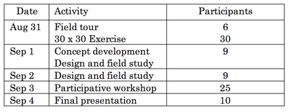
The charrette workshop was held over four consecutive days, from August
31 to September 3, 2015 at Kesennuma Kingüfs Village (Matsuzaki-omose 17-1). It is organized by Keio University
incorporated with Swinburne University of Technology, VHL University of Applied
Sciences, and EME Design under the support of Association of UNESCO Kesennuma, and Association of Livable City Kesennuma, and Australia Japan Foundation.
The schedule of the workshop is summarized in Table 1. Residents and
local activists were invited to participate in a üg30 x 30 Exerciseüh in the evening of August 31, and a participative
design workshop in the evening of September 3. Geographic data and documents
about the area were prepared beforehand for experts. Experts and participants
stayed at the facility, which is located in the design area, easy to walk
around and talk with local people.
Table 1 Process of the charrette workshop
The 30 x 30 Exercise is essentially a
brainstorming session with local residents and experts reflecting together on
how the region was 30 years in the past and how it could become 30 years in the
future (Roggema 2013). A total of 30 participants
broke into four groups and gathered around the tables bearing signs indicating
four themes: Population, Economics, Culture, and Environment. They discussed
the situation 30 years ago, wrote key words on ügsticky notes,üh and placed them
on aerial photographs. Several minutes of brainstorming was allowed for each
theme, with the post-it notes left on the maps. The participants subsequently
moved to the next table and added ideas during a seven-minute brainstorm about
their second topic. Eventually, all participants conducted a brainstorm on each
of the four themes. Finally, the team leaders at each table presented a
three-minute summary at each table of the results up to that point. Through
this process, each group reconfirmed things such as what existed in the area in
the past, what was lost, and what should be kept for the future. The output of this
process is summarized in Table 2. It is full of messages about the natural and
cultural resources.
The
second round of 30*30 Exercise is used for participants to picture the future
of the area in 2045. The participants were separated into four groups and each
group was assigned at a table with aero photo as base map. Each group is
required to draw their ideas on the base map for the reconstruction by using
the resources discussed in previous session. At the end each group had 5min to
present their proposals.
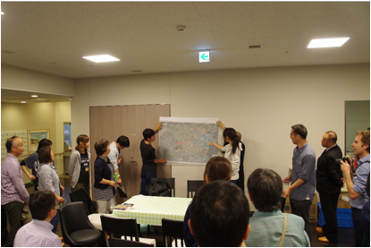
Fig. 6 30*30 Exercise and design proposals from participants
3. Design by expert team
The 30*30 exercise was the first time for residents from different
districts in this area to talk about the past and future together. It collected
rich information about the natural and cultural resources of the study area.
3.1 Understandings of the area
The design area is located at the mouth of Omose
River, a second-order river maintained by Miyagi Prefecture. The two sides of
the river belongs to different administrative
district, Matsuiwa District on left side and Omose District on right side. Each district was composed of
many communities with individual history. Depending on the loss and damage
during the tsunami, the residents demonstrates different responses. The Ozaki
area in Omose District where all of the houses were
swept and most the citizens evacuated to the temporary houses in a same
evacuation site moved speedily. Their lands was fully bought up by the
municipality, a sport park is going to be build. Situation in Matsuiwa District was quite complicated. The tsunami line
encroached residence and farmlands inland and separated the communities in low
land and upland. Afraid of the damage of tsunami, inundated families has given
up to live there and moved their houses to higher lands. There is a big
difference of concerns toward the reconstruction of the low land. Except
tsunami disasters, the area is prone to flood. A large part of the area was
under the sea level. The residence so far was protected well-developed drainage
systems and a pump station. Therefore, the reconstruction should not only think
about the protection from the sea but also the risks from mountains. The design
area at the river mouth should be considered by river basin, crossing the
administrative zones.
The development of the area origin to the Enunkan,
the old house of Ayukai
family and Japanese Linguist Naofumi Ochiai. The ancestor of the family was a vassal of Date Domain and moved from Yamagawa Prefecture 500 years ago. The old house Enhunkan, the family shrine Hachiban
Shrine standing at the terrace of hills, and Ozaki Shrine at the cape of Ozaki
area compose a gold triangle of the landscape of the area. People who have lived
in the area for hundreds of years have been fishing in the sea, cultivate the
paddy fields, excavated gold in mountains, and lumbered timbers in forest, and
developed a lot of folk tales and traditional activities. The reconstruction of
the design area should be placed in the historical and ecological context of
the entire from coast to the upper streams of rivers and mountains.
As the gateway to the city center from south coastal part of the
prefecture, multiple reconstruction projects at regional scale pass through the
area. Sanriku Highway from Sendai City to Iwate
Prefecture cut through the west of the area with an interchange. The national
route 26 runs through the coastal line from south to north under the Hachiban Shrine. One side of river dire is in
reconstruction from the fishery harbor to upper stream of Omose
River till the national route. All of the civil engineering projects are
rebuilt on the elevated basement higher than 10.0m, the height of the last
tsunami. The limited space of the area is going to be gridded by giant concrete
bodies with sunken between the grid. Each of the projects is planned and
constructed by different administrative agencies with collaboration each other.
The projects are planned and designed only to meet the specification of
engineering, lack of consideration of the harmonization with nature and
culture. Local communities and residents, the people who know the situation,
are outcasted from the process.
3.2 Concept of the design
The 30*30 Exercise and the field tours, the
design team understood that the area has rich natural and cultural resources;
it was a prone to disasters of tsunami and flood; reconstruction projects are
ongoing in part of the area with harmonization and collaboration. What the most
important is that we should change our
mindsets from protection from disaster to adapt to disasters. The design team understood that
reconstruction must, 1) remember the
past for the future generations; 2) reconnect
the sea with mountains; 3) reform the
rigid protection-based reconstruction to resilient reconstruction by adaptive
planning. The first one, remember, is
self-evident in a post-disaster reconstruction. Many cities have reserved
damaged buildings and ruins in memorial parks as materials for disaster
education. However, the implementation of the idea and utilization of the
facilities are context-dependent. We believe that the memorial should not be
the decoration or an exhibition of the history. It must be the life of the
people. The contents, the scale, and the location should be considered in
social ecological systems of the area. This comes to the second idea reconnect. The design area is a flood
plain at the mouth of Omose river.
The development of the flood plain backed to the gold mining the upper stream
of the river, which shapes the landscape largely, and reserved a lot of stories
in the gold rush time. The most famous one is the tale of Oiran,
a beautiful girl who made up by the flourish water of Omose
River as perfume to serve served gold miners. Many other local stories are
inherited in this region. Moreover, a collective relocation project is ongoing
in 2km upper stream. Most of the residents of the collective housing district
are those who lived in the design area. Therefore, the sustainability of the
river mouth must be considered with the river basin together. The realization
of this idea requires the third point: reform.
The disaster is a window for the area to rebuild transformatively.
Reconstruction projects should be placed in the social-ecological system of the
area in harmonized with nature and culture. This requires reform of
reconstruction concepts, reform of administration and reform of peopleüfs
mindsets. Reconstruction is not simply resuming the situation before the disaster.
It must be the construction for the development of next generations. It will be
a starting point of a new story, which reflected the lessons we learnt, and the
prospect we look for. Rather than the area itself, we should stand at the scale
of the whole city or above to think about what the area should be like, who
should be involved, what the functions should be included, and how it could be
realized. Landscape design is a platform to collect fragmented information,
place them on the table, realign them spatially, and communicate with people
for realization.
3.3 Design
Considering the geographic location, we set the goal of the
reconstruction is to rebuild the area as a complex of creative culture with a
combination of diverse components harmonized with En-unkan,
Hachiban Shrine, Ozaki Shrine and the bridge of Sanriku Highway with Oshima in
background. These components are,
1)
Old stories and
new stories related to remember,
(1) Cherry line planted along tsunami line
(2) A 93.3*93.3m2 memorial park embedded with
the streets before the disaster of the area in 1 to 10 scale
(3) Use of debris material to shape the old street
patterns and house locations/foundations
(4) Think water as a friend to live with and give it more
space to absorb risks by traducing water into the ground 0 area.
(5) Receive and downsize floods by dissipative structure
of coasts
2)
Reactivating
natural and cultural resources by reconnect,
(1) visually
anchor Enunkan - Hachiban
Shrine - Ozaki Shrine, and the new monument as a diamond of the landscape
(2) Connect the hinterland
with the seaside by extending the hills to the sea
and allow water inlands
(3) Mitigate flooding
from mountains by widening the streams
(4) Create history sites
(cat stone, mirror stone), along the route inland
(5) Ask relocated people
to garden their former house in excavation zone
(6) Bicycle path,
connecting hills, historic story-points with new monument, shrines and sports park
3)
Embrace regional
infrastructure for implementation by reform,
(1) Use the levee in construction along Omose River as access promenade to the central square
(2) Build bus stop and parking at the intersection of the
national route and the levee as entrance
(3) Shape up the beach with sports park including football,
tennis, baseball, swimming with amphi-theatre for
spectators
(4) Allow relocated people to garden their former house
(vegetables, flowers)
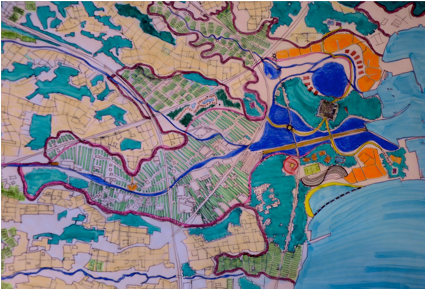
Fig.6 The landscape design: Remember,
Reconnect, Reform (Central Area)
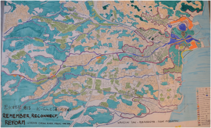
Fig.7 The Landscape Design (The entire
Area)
3.4 Communication with participants
The residentsüf design workshop was held at
the end of the design charrette process. The findings of the design team were
presented in a presentation to the group, then a plasticine
model was created to show the impacts of the design in three dimensions, and
finally a participatory design workshop was held with citizens.
1) Presentation
preparation
In the preparation
process for the presentation the overall design process was reviewed, which
helped to clarify the message of the design proposal. Through the 30 x 30
Exercise, the flow of the process became clear. Participants had the
opportunity to ügrememberüh the
experience and history of area. The design for reconstruction from the disaster
presents the opportunity for the regional natural and cultural intrinsic to be ügreconnectedüh. After remember and reconnect,
the ügReformüh can occur. By ügreformüh two aspects are meant. First,
the people reform the way of living for sustainability, and second, people
could physically reform to their land by collaboration. This conceptual
approach was presented to the residents, and then, in order to incorporate the
residentsüf perspectives, three-dimensional models were created using plasticine to visualize the outcomes.
2) Visualizing
the design concepts using three-dimensional models
Plasticine is useful as a tool to express the ideas of
participants (Roggema, Vos,
& Martin, 2014). Using plasticine,
which is available everywhere, participants could visualize the connections
between the spatial components of identity in the region, and they could design
their desired configurations of added and existing landscape elements. The
landscape elements that were designed on paper suddenly become
three-dimensional. Anyone can easily join, because of the common childhood
experience of playing with clay, the material is inexpensive, and it
facilitates dynamic communication.
3) Design
workshop
A participatory design
workshop was held at the Ota Community Center. The participants consisted of
the same groups as in the 30 x 30 Exercise. Before the workshop, the design
proposals, the landscape plan, and a demonstration of the plan by plasticine models were presented and exhibited at the
venue. At the start of the workshop, the design team gave a presentation on the
theme of ügRemember, Reconnect, Reform.üh After questions and answers, participants were
divided in four groups and asked to use the plasticine
to express how they envision a plan for reconstruction, on top of aerial photos
(Fig.8). Because of the fact that the participants were informed and saw the
expertsüf designs and the three-dimensional models in advance, the workshop went
smoothly. Students, workers, and seniors, all generations from various
occupations, worked together as unified teams to think about the regionüfs
future, expressing their ideas by use of plasticine
and placing the items physically on the aerial photograph. It was a dynamic
exercise, with participants adjusting each otherüfs creations and their spatial
relationships. Some participants asserted their ideas strongly and sought
agreement from everyone, while others yielded more and made an effort to
consolidate the discussions. All of the teams were keen to develop their plans.
This session was an important opportunity for communication and to understand
what others were thinking.
At the end, each team
leader made a presentation, explaining the spatial alignment and proposal
developed by the group. For many students from local high school this was the
first time to participate in such a design game and to speak in front of a
group of people. They proudly introduced their teamüfs work and they felt happy
with such a positive experience.
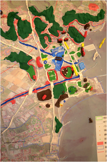
Fig.7 Plasticine Model made by participants
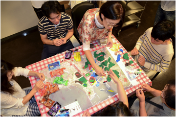
Fig.8 Participants are working together
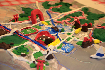
Fig.8 Close-up of the plasticine model
4. Discussion and Conclusions
It was first time to hold the participate
workshop for the reconstruction in Matsuiwa Area
which bring people together from different district. Last plan has been made
with the help of Tohoku Gakuin University and
delivered to the municipality four years ago. At that time, 95% of the
residents have chosen to move to higher lands while only 2.5% of residents
selected to return. Without request from residents, the municipality cannot do
anything. On the other hand, residents thought that they have sent their
requests and the city government should have move on. Unfortunately, nothing
has happened during the period.
The design proposal was built on the
analysis of the situation at the regional scale and river basin scale.
Participants of the workshop were delightful to see an alternative from the
conventional one, a simple collection of infrastructure projects and the
requests of residents. By change of ideas, the city could be safer, livable and
smarter.
It is surprised that the participants showed
strong concerns on cultural and recreational facilities while the safety was
not touched very much in the preliminary design and final design workshop. This
may reflect that residents would take the safety granted even in a city not
long after a disaster. On the other hand government has paid more attention on
safety issue by swift reconstruction of levee and the elevation of roads. This
difference might be the reason of the gaps between residents and municipality. Participative
design workshop is effective to visualize all of the projects and information
in one map.
Acknowledgements
This project is granted by Academic Exchange Grants of the Graduate
School of Media and Governance, Keio University in fiscal year 2015. The charrette design workshop was supported by the Associate of Sumiyosa Kesennuma City.
We are grateful for Kingüfs Garden Miyagi Ltd to provide us the accommodation of
Kingüfs Village during the workshop.
Roggema,
R., Vos, L., & Martin, J. (2014). Resourcing local communities for climate
adaptive designs in Victoria, Australia. Chinese Journal of Population
Resources and Environment, 12(3), 210–226.
doi:10.1080/10042857.2014.934951