慶應義塾大学 政策・メディア研究科 修士課程2年
森 正彦
ログイン名:mmori
■研究概要
本研究の目的は,地球上に存在する生物についての画像情報を対象とした時空間・マルチメディア分析により,環境変化,環境状況に関する新たな大局的状況認識,知識の獲得を可能とする”生物生息情報分析データベースシステム”を設計し,構築することである.本システムは,利用者によって示される分析対象の生物の断片的な情報(その生物の画像),および,分析対象の情報源をクエリとして受け取ると,それらのクエリを分析し,自然環境に存在する生物に関する時間的,空間的,および,意味的な内容を検索,分析し,自然環境に存在する生物についての大局的な状況,時空間的変化についての知識抽出を実現する.本システムを構築するために,
①画像の色彩・時空間分析,可 視化による対象物特定機能,
②大局的情報取得のための多元的地図可視化機能,
③生物マルチメディアデータからの大局的意味抽出機能
を実現する.本システムの 特徴は,分析対象生物の画像についての色彩分布及び生物生息の時間的変化や移動についての時 空間分析機能と可視化機能により,分析対象生物を対象としたマルチメディア計量による環境変 化,環境状況についての知識獲得を可能にする点にある.本研究の意義は,ユーザが撮影した生物 生息情報を収集し,それらを時系列的にマッピングすることにより,生物生息情報の大局的に可視化・分 析し,環境の変化の観測を実現する点である.また,生物生息情報の変化と同時期に発生した環境変化 を分析し,環境の変化が与える生物生息への影響の分析が可能となる.
■活動・成果報告
①ユーザが撮影した画像に関し,時空間情報や生物関連情報などの文脈ごとに統合し,その情報から知識を獲得可能なシステムの構築を行った.同じ文脈で集められたデータ集合に対し,マルチメディアデータの分析を行うことにより,生息情報等これまで獲得が可能であった知識に加え同時間,同地域に存在する生物の色彩的特徴の分析など,新たな知識を獲得することが可能となった.
②上記のシステムを用い,同地域における生物の色彩的特徴を抽出し,年ごとに比較を行うことによりこれまでは獲得が難しかった新たな知識の獲得を可能とする、マルチメディア分析による時系列的な生物情報の変化を抽出可能なシステムの実装を行った.ある色彩的な特徴を持った生物を抽出し地図にマッピングすることにより,生物の色彩的な特徴に関する世界的な変化を大局的に把握することが可能となった.
③生物的特徴に基づく新たな知識の獲得方式についても検討し,実装を行った.本研究において,海辺,森林等の生物の生息する環境の特徴と生物の色彩的な特徴との関連などこれまでの対象生物の研究のみ,またはマルチメディアデータ処理の研究のみでは獲得が難しかった知識の獲得を実現した.
④生物識別マルチメディアDB システムによる可視化機能による,環境変化測定システムの実装を行った.本システムの色彩分析,および,時空間分析を用いることによりリアルワールドにおける生物の変化を把握することが可能であったが,この機能を用いることにより,リアルワールドにおける環境変化の観測システムを実現した.
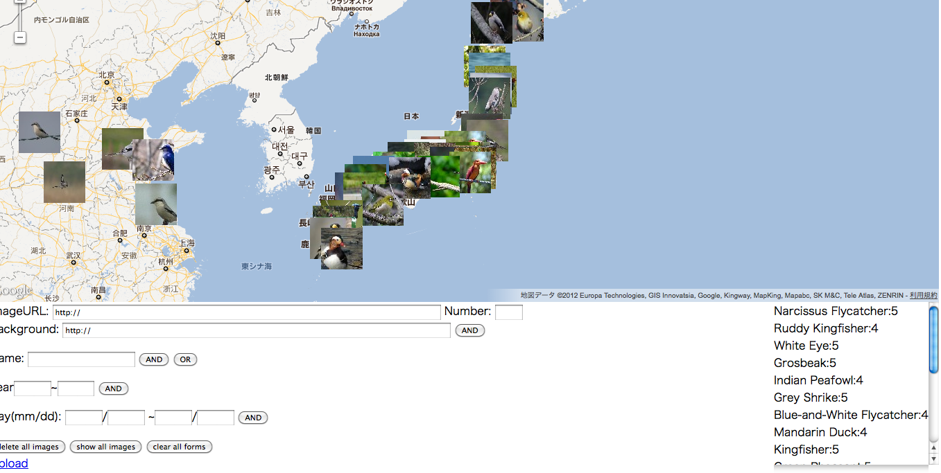
図1 マッピングによる生物情報可視化及び関連情報検索の実装結果
■学会発表等
今年度,以下の学会において研究発表を行った.
IEE ICT and Knowledge Engineering 2012(タイ・バンコク 2012年11月)
○発表テーマ
A Bird-World Image-Map System with Spatiotemporal and Color Analysis Functions
○論文・発表概要
A bird-world image-map system is a new geographical system with spatiotemporal and color analysis functions. This System is like a “Multimedia Encyclopedia”, which makes it possible for users to share comprehensive birds’ knowledge, such as the name, habitat, migration and activity period of birds, by creating birds’ database from users’ input and fragment data on cyberspace and visualizing the datasets on a set of chronologically-ordered world-maps. Because of the rapid progress in multimedia, mobile and GIS technology, various kinds of information resouces about natural environments of the real world can be accessed in a cyber space. In this situation, it is important to support users to acquire valuable knowledge that expresses user’s fragmentary information about the real world and adequate information on the cyber space. In order to provide and collect birds’ information in the world and create digital maps, this system realizes the functions for identifying a bird contained in a picture image input by a user through the global analysis of temporal, spatial and color information of images within a selected domain. In addition, this system makes it possible for users to share comprehensive birds’ knowledge, such as the habitat, migration and the activity period of birds by creating birds’ database from users’ input and fragment data on cyberspace and visualizing the datasets on a set of chronologically-ordered world-maps. This system is also applicable for natural environment analysis by visual observation of ecological form, distribution, history and change of living-things, such as global habitats and migration.