<<Taikichiro Mori Memorial
Research Fund>>
Graduate Student Researcher Development Grant Report
Research Project: An
Imagination-based Image-Retrieval System and Its Application to Spatio-Temporal Analyzers with 5D World Environment Map
Project Researcher: Nguyen Thi Ngoc Diep
Affiliation:
1st year Master’s student, Graduate School of Media and
Governance, Keio University, Japan
Research Abstract
In this study,
I develop a new imagination-based image-retrieval system with the integration
of logical and correlation computing functions. The important aim is to
realize image retrieval by reflecting imaginations appearing in a human
brain. Furthermore, I will design and implement Spatio-temporal
analyzers in 5D World Environment Map with this image-retrieval
system. The 5D world environment map is a new cyber-physical environment for organizing, analyzing and
retrieving context-dependently
environmental information based on human
imaginations with time-series multi-geographical views. This
application provides users with 5-dimensional information overview:
spatiotemporal 4 dimensions plus the multimedia data related to physical
environment. The main features of the 5D world environment map system are: (1) to
dynamically create various context-dependent patterns of multimedia stories of
environment on spatiotemporal spaces according to a user’s imagination
processes, and (2) to dynamically extract social-environmental rules by
using feature selection and support vector machine methods. This
application provides users visual tools to semantically analyze and discover
new models of the ecological and global environment.
The research theme is derived from the need
of integrating information and
communication technologies (ICT) and real world to solve multidisciplinary
problems. Especially, since I am joining the Cyber Informatics program
and Environmental Innovators course, I will have chances to reflect the environmental fieldwork activities into
my ongoing research on imagination-based information retrieval methods and
spatiotemporal 5D world map. As the basis of this study, I have presented 4 international conference papers(IASTED
SEA 2010 USA, IADIS e-SOCIETY 2011 Spain, KCIC 2012 Indonesia, and EJC 2012
Czech Republic) from
2010 to 2012, SFC ORF 2010
and received many good assessments. I also received SFC Student Award for “Excellent
Graduation Project” for the project named “5D World PicMap:
Imagination-based Image Search System with Spatiotemporal Analyzers”
(supervisor: Yasushi Kiyoki) on March 2011.
Research Activities and Results
Data Collection and System
Implementation
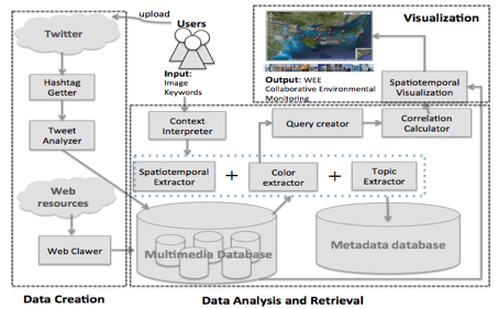
I have implemented a new collaborative mashup system, named “WEE – Web-based Environmental
Education, for global environmental monitoring research and education in which
all participants could associatively organize multimedia data about physical
environments and visually monitor various environmental topics based on time-
series multi-geographical views. The main features of this system are: (1)
collaborative multimedia database creation using “social sensors”, (2)
information aggregation from Web resources, (3) content-based image and
document retrieval, and (4) big-picture visualization with spatiotemporal view
controllers and content-based image, document retrieval.
Participative Database Creation Method using Social Networks
Primal social networks such as Twitter or
Facebook were not designed for collaboration but their usability for
conversational purposes has been varying from daily communication to crowd
sourcing. Together with the development of information communication technology
devices such as smart phones, nowadays SNS users can easily share information
from anywhere and at anytime. Based on these technology backgrounds, I have
designed a new usage of Twitter, one of the most popular SNS, as an educational
tool for collecting environmental database while fostering students
participating in classes’ activities.
Figure 1 shows how to create cross-topic shared
databases with participation of students. In one class, a teacher divides
students into some groups, then raises one topic for each group and gives one
hash-tag (#topic_tag) to each group. Each student of
each group will collect information relating to the given topic and upload data
to Twitter (tweeting a tweet). The students can
conduct these activities as group works. Besides, the students can go out for fieldwork
activities with their smartphones to take photos and real time tweet some
tweets. Or they can collect information from the Internet and tweet those by
Twitter web interface. Every tweet is tweeted required to specify location,
timestamp and include the given hash-tag, and other multimedia data such as
photos or description text relating to the topic. One module in my system is
implemented to get all tweets having a hash-tag (#topic_tag)
and store data to one database table for one topic. These shared databases are
used for spatiotemporal visualization onto the world map so that the users of
this system can obtain the broader view of topics using others’ collected data
by the time data are uploaded.
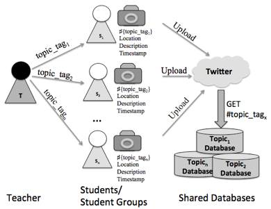
Figure 1. Participative Database Creation using Twitter in WEE System
System Architecture
Experimental results via Educational Scenarios
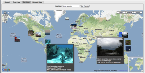
Shared-view interface of WEE system for environmental monitoring using
collaborative database
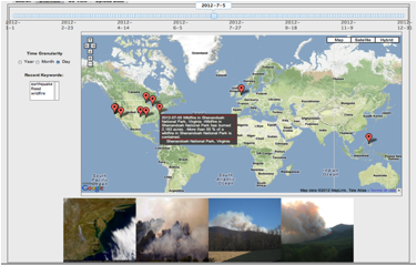
Global Environmental Monitoring by Timeline by big-picture
visualization with spatiotemporal view controllers of WEE System: (a)
“desertification”, “flood”, “ocean pollution”, “deforestation”, and “wildfire”
in July 5th, 2012
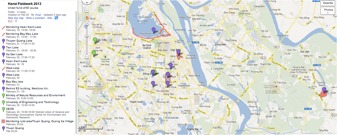
Fieldwork activities
Inspired by a report of the Centre for the
Environment and Community Research (CECR), part of the Vietnam Union of Science
and Technology Associations which stated approximately 80% of the lake surface
area in Hanoi are disappeared during 50 years (1983-1996)
and the health of lakes have been becoming worse. I have conducted a fieldwork
at Hanoi, Vietnam. This activity is also
a required subject of Environmental Innovator course and the course provided me
transportation financial support to conduct it. The vulnerability of the lakes
is highly related to the urbanization and the lack of the public awareness. I
mainly monitored the ecological conditions and socio-economic impacts of three
important lakes in Hanoi: West lake, Hoan Kiem lake and Bay Mau lake. West Lake is the largest lake
of the capital and a popular place for recreation with many surrounding
gardens, hotels, villas and other entertainment centers. Hoan
Kiem Lake is a lake in the historical center of Hanoi
and also one of the major lake, which serves as a
focal point for its public life. Bay Mau Lake is a lake inside the Thong Nhat Park, one of the largest parks in the capital. I also
monitored some lakes, ponds at a rural area around Thuan
Quang, Duong Xa village, Gia Lam district, Hanoi City,
Vietnam. At the end of this fieldwork, I visited and studied about
environmental policies at the Centre for the Environment and Community Research
(CECR) and Vietnam Environment Administration, Ministry of Natural Resources
and Environment. The following figure shows my routes and spots during my
fieldwork.
Publications
[Journal] D.T.N Nguyen and Y. Kiyoki,
“An imagination-based query creation method for image retrieval,” Information
Modelling and Knowledge Bases XXIV, p. 201, 2013.
[Book] Kiyoki, Y.,
Sasaki, S., Nguyen, N. T., Nguyen, D.T.N., "Cross-Cultural Multimedia
Computing with Impression-based Semantic Spaces", Conceptual Modelling and Its Theoretical Foundations, Lecture notes in
Computer Science, Springer, pp. 316-328, 2012.
[Proceeding] Nguyen, D.T.N., Sasaki, S. and Kiyoki, Y.: “WEE: A Mashup
System Using Social Networks
For Collaborative Environmental Monitoring
Education With Spatiotemporal Analysis And Visualization”, Proceedings of the
IASTED International Conference Web-based Education (WBE 2013) February 13 -
15, 2013 Innsbruck, Austria.
[Submitting] Nguyen, D.T.N., Sasaki, S. and Kiyoki, Y.: “A Time-Constrained Image Retrieval System
Towards Big Image Database Realization”, IEEE International
Conference on Image Processing (ICIP 2013),
September 15-18, 2013 Melbourne, Austrialia.
[Research
Report] Nguyen,
D.T.N., Sasaki, S. and Kiyoki, Y.: "5D
World Environmental Map System with Spatiotemporal Analyzers for Collaborative
Research and Education", Japanese Society for Information and Systems in
Education (JSiSE) Research Report, Hokkaido July
2012.
[Poster] Nguyen, D.T.N., Sasaki, S. and Kiyoki,
Y.: “Visualization and Analysis of Global
Environmental Change with Multimedia Retrieval”, International Forum for
Sustainable Asia and the Pacific (ISAP 2012) Student
Poster Session.
Future Works
I have collected a lot of data after the
fieldwork at Hanoi City, Vietnam. From now on, I would work to refine the data
and improve WEE system to allow users to access to the data properly and
helpfully.
Acknowledgements
I would like to express my gratitude to Taikichiro Mori Memorial Research Fund, which supports great financial policies to researchers like me to make
progress on our ways.