Taikichiro
Mori Memorial Research Grants
Graduate Student Researcher
Development Grant Report
February 2015
Research
Project: Organic Infrastructures in Human
Settlement Systems: Towards a Generic Spatially Explicit Model to Simulate
Informal Path Formation Process in a Self-organized Landscape
Researcher: Hossein Vahidi
Affiliation: Graduate School of Media and Governance, Keio University, Japan
Email: vahidi@sfc.keio.ac.jp
Human
settlements have been classified into those which have been grown in an
unplanned and organical process and those which have
been developed in a planned and artificial approach. In the organic method of
human settlement expansion, the settlement has been grown mainly based on
continues collaborative activities of the residents in evolutionary approach
overtime without any top-down planned approach.
The
organic structure can be observed in the human settlements in two forms: The
historical organic textures in rural and urban planned settlements and the
informal settlements.
Some
of the historical districts in the planned rural and urban areas were expanded
as the result of an unplanned process through the history. These types of
residential areas have been expanded in an informal process until the recent
centuries and decades when the role of the government and public sectors in the
top down planning of the settlements has been increased. Therefore as the
unplanned approach of urban growth has been transformed to the planned approach
in these settlements in the recent era, the organic growth in these historical
settlements has been mostly stopped at present. However, as this type of
available organic structures have formed the backbones of the new planned
settlements, the irregular patterns in the form and morphology of them still
can be partially or totally observed in some of the recent settlements.
In
contrast with the organic historical textures where the growth process of them
usually has been stopped long time ago, the informal settlements are live
examples of organic growth of the settlements in our era.
Lack
of access to proper transportation infrastructure is one of the main
characteristic of the settlements where expanded organically and in unplanned
approach.
In
the absence of developed formal infrastructure in the unplanned settlements,
the informal network of infrastructure will be formed by settlers. This
informal human trail network undertakes the role of connection between
significant destinations and also provides the accessibility of zones and
facilities for settlers in the settlement (Figure 1, Figure 2).
Informal formation of human trail system
between an origin and a destination has a bottom-up nature. Basically, the
process starts when a track is created by a single settler in the form of
physical signs like compacted ground or damaged and trampled vegetation. This track will be developed into a footpath
if it has been used frequently by many people.
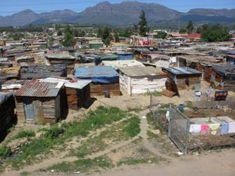
Figure 1. Informal
Infrastructure in Informal Settlement
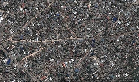
Figure 2. Informal
Infrastructure System, Dar es Salaam, Tanzania
Not
only in the settlements with organic and informal nature of expansion, but also
the informal trail formation process can be observed in formal and planned
environments (Figure 3, 4 & 5).
A
desire path also known as a desire line or social trail is a technical term which
has been applied for a path that formed as a consequence of pedestrians walking
in the formal urban environment by urban planners for almost a hundred year.
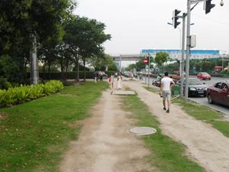
Figure 3. Informal
Infrastructure Formation in a Planned Environment, Beijing, China
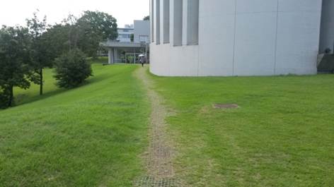
Figure 4. Informal
Infrastructure Formation in a Planned Environment, SFC Campus, Keio University,
Fujisawa-shi, Japan
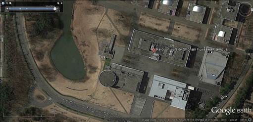
Figure 5. Informal
Infrastructure System in a Planned Environment, SFC Campus, Keio University,
Fujisawa-shi, Japan
Previous
agent-based models for simulation of infrastructure growth mostly concentrated
on the modelling of planned and structured infrastructure growth that are
emerged in a top-down approach. So, the existing agent-based models cannot
fully handle the simulation of the informal growth and organic growth of
infrastructure in the unplanned and planned settlement.
To
address the above-mentioned research gap, this was studied the formation of
informal infrastructure under two main categories.
In the first category, the Direct Dynamic of
Informal infrastructure growth have been studied. Direct dynamic of informal transport
infrastructure (trail system) formation from an origin to a destination has a
bottom-up nature. Basically, this process starts when a track is created by a
single settler in the form of physical signs such as the compacted ground or
damaged and trampled vegetation. This track will be developed into a footpath
if it has been used frequently by many people.
Bottom-up process of direct growth in infrastructure system is
initiated from the different daily behaviours of
settlers and is influenced by various social, economical
and physical factors.
This dynamic of trail formation is basically the predominant
dynamic of path formation between origins and destinations in the informal
settlements, however during the middle stages of extension stage in informal
settlement (construction of new houses in the open space of the settlement) and
latter during densification (infilling) stage of formation and growth of the
informal settlements, most of these trails will be disappeared.
In this context, the buildings would be built on the track of
footpath if that footpath has used only by a few number of dwellers and not
consolidated enough in the settlement. Therefore, at the middle stages of
extension dynamic and at the beginning of informal settlement densification
stage in the growth process of informal settlements, mostly the considered void
spaces by the dwellers between the dwellings will take the burden of
channelizing and addressing the daily trips in the settlement (for more details
see section 3.2).
Consequently, in the informal settlements with dense and bounded
configuration and rapid rate of growth, the direct dynamic of informal
transport infrastructure formation might be neglected (if only we need to model
and simulate the final pattern of infrastructure system and final spatial
pattern of the settlement) in the most cases, as usually they do not have a
considerable effect on the final emergent spatial pattern of informal
infrastructure and the spatial pattern of informal settlement.
However, in some exceptional cases, the direct dynamic of informal
transport infrastructure formation may considerably affect the final emergent
spatial pattern of informal infrastructure and the spatial pattern of informal
settlement.
In first type of these exceptional cases, the informal
infrastructure is formed between the informal settlement to a common
destination between the different dwellers (such as water well, formal road
etc.) located outside of the current extent of the settlement. In this context,
if the informal path has been used frequently by the different dwellers
frequently, the formed trail has a chance to be consolidated over time. In this
sense, a well consolidated trail has a high chance to be recognized by the
newcomers as a major path that should be preserved in the horizontal growth
stage of informal settlement (Figure 5). This type of informal transport
infrastructure can have effective impact on the future direction of horizontal
growth of informal settlement and as therefore the spatial pattern of informal
settlement as the newcomers usually interested to construct their houses
adjacent to the consolidated paths.
In addition to this, an informal infrastructure that is emerged
based on the direct dynamic also might be preserved in the informal settlement
with a dispersed pattern or in the settlement with an slow growth rate if the
path is frequently used by several dwellers overtime and the trail would find
the chance to be consolidated enough and to be recognized as a major path
before the construction of new dwellings over the free space.
The formation of desire path and the
infrastructure in the formal settlements also follows from Direct Dynamic of
Informal infrastructure growth. The
trail formation process triggered when a track is created by a single
pedestrian in the form of physical signs in the background of environment and
overtime, this single track will be developed into a footpath and a trail if it
has been used frequently by many pedestrians.
So for simulation of the direct
dynamic of infrastructure growth, a spatially explicit agent-based model has
been developed to simulate the human logic and behaviors in the formation of
informal trails under the different settings of environmental conditions in a
Self-organized Landscape (Figure 6).
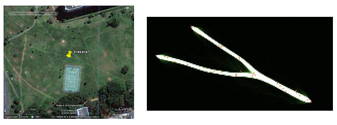
Figure 6. Informal
Infrastructure Formation in a Planned Environment, Brasilia, Brazil (Left).
Result of Agent-based Simulation of Informal Infrastructure Formation in Study
Area (Right)
In the other level, this research studied the
Indirect Dynamic of Informal Transport Infrastructure Growth. This
dynamic mainly is observed in the settlements with almost ordered settlement’s
spatial pattern (with non-dispersal spatial pattern) in the fragment level
which have bounded extents with a fast extension and densification dynamic. For
modelling of the final pattern of informal transport infrastructure in this type
of settlements, the formation of informal transport infrastructure could be
considered as the function of settlement construction (housing) dynamic. Based
on this definition, when a settler constructs his/her house (according to
his/her adopted pattern of housing) in the first row of fragment, usually
he/she considers a void space (as a path) parallel to his/her house and this
trend has been adapted by other new dwellers in the first row of houses
construction in the fragment. This system also adopted by the next settlers at
the next row of construction in the fragment and so on and in this sense the
transport infrastructure is indirectly developed and penetrates between the
houses in the term of void spaces to provide the accessibility of building
blocks. For connection
of two parallel contiguous building rows (or dwellings) and providing the basic
or secondary accessibility of them, usually, the void space (s) has (have) been
considered between two rows by the dwellers in the appropriate distance(s).
To our knowledge, in the context of fine-scale modelling of the
informal settlement growth, up to now, only two research have been conducted by
Iqbal (2009) and Augustijn-Beckers, et al. (2011). In
both of these proposed models, the spatial pattern of informal infrastructure
was fully adopted from the final state of transport informal infrastructure in
the reality. Therefore, for the means of simplification, they assumed that the
informal infrastructure has a static nature and fully existed in the area at
the beginning of simulation, therefore they only concentrated on developing a
model for fine-scale simulation housing (extension and infilling dynamics).
In this context, it was suggested that the current existing
fine-scale housing models can be developed by a sub-model for modelling of the
indirect informal infrastructure growth pattern (in the context of creating the
void spaces in the settlement) to improve the current settlement growth models
by considering the realistic behavioral rules of dwellers in the indirect
formation informal transport infrastructure.
It
was mentioned that the indirect growth dynamic of informal transport
infrastructure could be considered as a sub-dynamic of informal housing
dynamic. As the existing developed models for simulation of the informal
settlement growth are not available for us, so in the absence of these
implemented models, a simple and limited agent-based model has been developed
and implemented as a prototype to model the housing mechanism in the context of
informal settlement in order to test the validity of the proposed dynamic for
the indirect growth of informal transport infrastructure (Figure 7, Figure 8).
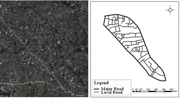
Figure 7. Satellite Image
(Left), Transport Infrastructure Map (Right); Manzese,
Dar es Salaam, Tanzania
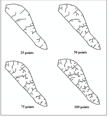
Figure 8. Result of
Simulation for Different Runs of Prototype Model
The output of this study has been published partly in the International Archives of the Photogrammetry, Remote Sensing and Spatial Information Sciences, Volume XL-2/W3, 2014, another comprehensive paper has been prepared to submit for a scientific journal. Finally, I would like to take this opportunity to express my sincere gratitude to Mori Fund Steering Committee for selecting me as one of Mori Grant recipients and provide this unique opportunity for me to conduct this research.